VANCOUVER, BC, Oct. 19, 2021 /CNW/ – Libero Copper & Gold Corporation (TSXV: LBC) (OTCQB: LBCMF) (DE: 29H) is pleased to announce the commencement of exploration activities on its Mocoa porphyry copper-molybdenum project with airborne geophysical and LiDAR surveys followed by a large scale soil sampling program. The last exploration and drilling activities at the Mocoa project were conducted by B2Gold in 2012. Libero Copper acquired the project in 2018 and calculated a constrained inferred resource at Mocoa which contains 4.6 billion pounds of copper in 636 million tonnes grading 0.45% CuEq*.
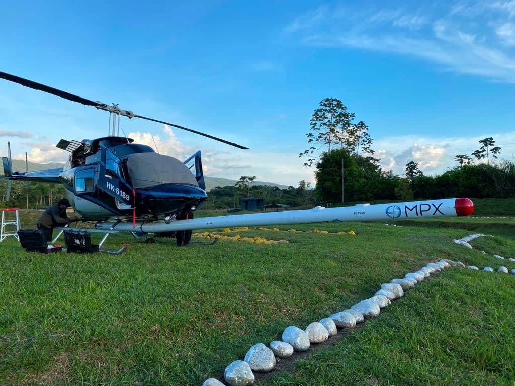
MPX Helicopter – Mocoa, Colombia (CNW Group/Libero Copper & Gold Corporation.)
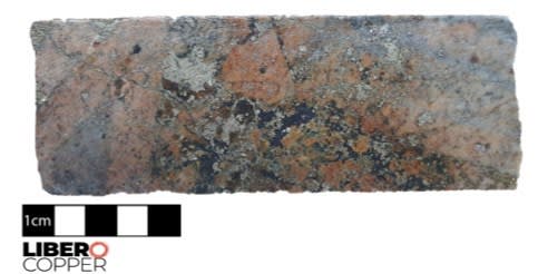
Figure 1 – Magmatic-hydrothermal breccia with bornite, magnetite, quartz and K-spar matrix. Core from Mocoa, with potassic alteration and high magnetite content (222 metre depth). (CNW Group/Libero Copper & Gold Corporation.)
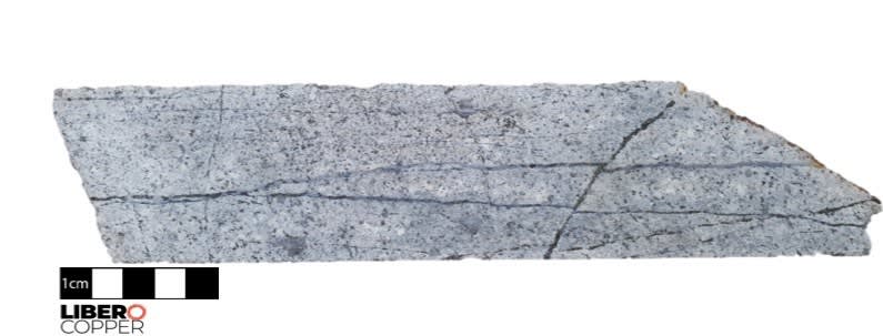
Figure 2 – Transitional sericitic alteration overprinting prograde potassic alteration, low magnetite content (134 metre depth). (CNW Group/Libero Copper & Gold Corporation.)
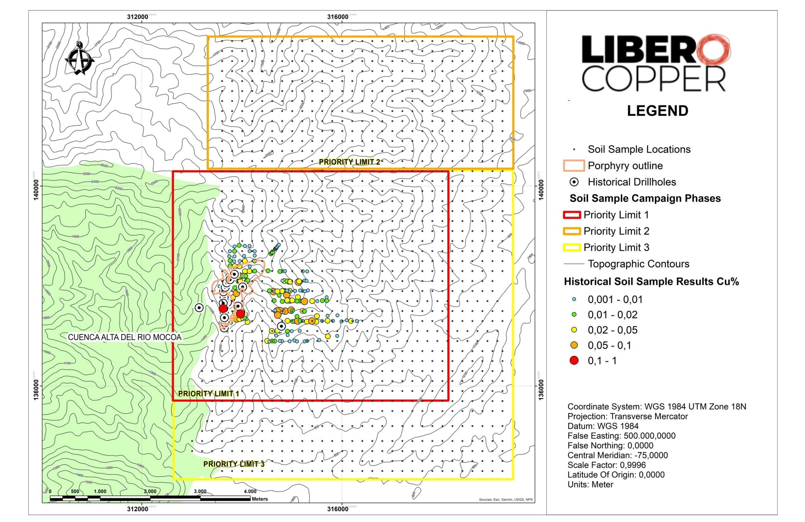
Figure 3 – Plan map highlighting the geophysical and LiDAR survey area, as well as the three phases of the planned soil survey grid and the distribution of soil samples relative to the historical drilling. (CNW Group/Libero Copper & Gold Corporation.)
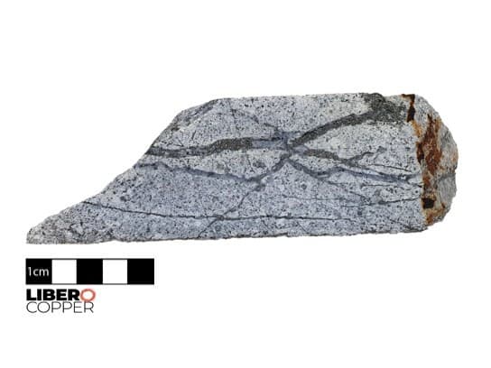
Figure 4 – Transitional sericitic alteration are overprinting the prograde potassic alteration, where D-type pyrite-bornite-hypogene chalcocite veinlets associated with white sericitic alteration are overprinting and cutting the A-Type and B-type veinlets (132 metre depth). (CNW Group/Libero Copper & Gold Corporation.)
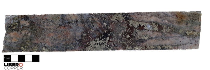
Figure 5 – Magmatic-hydrothermal breccia with bornite, magnetite, quartz and K-spar matrix, with potassic alteration and high magnetite content (214 m depth). (CNW Group/Libero Copper & Gold Corporation.)

Figure 6 – Magmatic-hydrothermal breccia with a muscovite-pyrite rich matrix (194 metre depth). (CNW Group/Libero Copper & Gold Corporation.)
Highlights
- MPX Geophysics has recently completed high-resolution airborne magnetic-radiometric and LiDAR surveys over an 8,100 hectare area.
- Initial 1,450 sample soil sampling program planned for Q4 2021 to assist in identifying additional porphyry centers and enhance drilling vectors.
- Core relogging suggests Mocoa is multi-pulse system with a high-grade copper magmatic-hydrothermal breccia associated with bornite-magnetite mineralization, overprinted by late white mica alteration associated with hypogene chalcocite-bornite mineralization. The prolific Jurassic porphyry belt which hosts Mocoa is a host to Mirador, San Carlos, Panantza, and Solaris’ Warintza.
- Significant expansion potential as the resource is open both along strike and at depth, and the porphyry system appears to trend in the northeast direction. The current resource model for Mocoa is roughly cylindrical with a 600 metres diameter, and high-grade copper-molybdenum mineralization continues to depths in excess of 1,000 metres. Historic drilling includes 0.67% CuEq* (0.49% Cu and 0.06% Mo) over 634 metres and 0.59% CuEq* (0.44% Cu and 0.05% Mo) over 779 metres.
- Historical soil sampling shows an untested porphyry copper target 1.3 kilometres south-east of the resource zone. This copper and molybdenum soil anomaly is greater than 1.5 kilometres in diameter and is comparable in extent and intensity to the response above the existing Mocoa resource.
“Boots on the ground exploration work at Mocoa has officially begun. The exploration team is working diligently to gain a deeper understanding of the deposit. Having advanced the geological model through detailed re-logging of existing core, fieldwork is now required to ensure our upcoming drilling program is a success. The speed at which a collaborative environment with local communities has been established speaks volumes for the professionalism of each member of the Colombian team and their commitment to the company’s core values of respect, responsibility, and our ´Good Neighbor´ operating philosophy,” comments Ian Harris, President & CEO. “The dedicated effort of meaningfully connecting with our communities is now adding value to the project through exploration. We cannot understate our excitement to further demonstrate our commitment to maximize local benefit through actions, transparency and the incorporation of local knowledge into work plans.”
Airborne Magnetic-Radiometric Survey
The magnetic-radiometric survey covered 8,100 hectares and 809.5 kilometres of linear survey with 100 metre line spacing and 1 kilometre spaced tie lines. The survey will assist in lithological and structural mapping of weathered and covered areas. Relogging of core has identified high concentrations of magnetite in core associated with potassic alteration (Figure 1) and as well as transitional sericite alteration associated with low magnetite present (Figure 2), suggesting magnetics may help target exploration for other porphyry centres. The radiometric survey will further assist with potassic alteration mapping and delineating intrusive phases. The team plans to use the new data to characterize the geophysical signature of the already drilled resource area in order to identify similar zones for resource expansion as well as to generate new exploration targets. Porphyry copper deposits often form in clusters, especially in the Jurassic porphyry belt that hosts the Mocoa deposit.
LiDAR Survey
The LiDAR survey will be used to generate a highly accurate, digital elevation model data for topographical mapping in diverse types of terrain and vegetation. The survey will generate high value data for structural mapping, drill and drill platform planning, and geomorphological evaluation, in addition to multiple socio-environmental studies such as forest distribution mapping, baseline control for reforestation management, and mitigation of vegetation disturbance.
Geochemistry & Soil Sampling
The soil sampling campaign will consist of three phases and 1,450 samples covering 5,912 hectares commencing with a systematic 200 metre by 200 metre grid. Phase 1 will primarily focus on optimizing drill hole planning from the pre-planned platforms, Phase 2 on resource expansion, and Phase 3 on new target generation. Figure 3 illustrates the planned areas for soil sampling.
The exposure of solid outcrops of copper-molybdenum porphyries in tropical areas is very low, and therefore systematic soil sampling can be used to generate a consistent data set to support exploration. The grids will be modified to increase sampling density in areas where initial anomalies are detected. Soil sampling will be a key tool in identifying new porphyry centers that commonly cluster above underlying parental magma chambers. Targeting from the soil sampling data will focus on Cu-Mo-Au metals but also pathfinder elements such as Bi-Te-As-Sb-W-Tl-Hg-Zn that will create vectors towards porphyry centers.
Libero Copper is currently finalizing right-of-way agreements with local landowners for establishing access routes and camp facilities closer to the target area.
Core Relogging and Interpretation
Recent core relogging and investigation has developed a deeper understanding of the deposit. Transitional sericitic alteration overprints the prograde potassic alteration, where D-type pyrite-bornite-hypogene chalcocite veinlets associated with white sericitic alteration are overprinting and cutting the A-Type and B-type veinlets (Figure 4). The magmatic-hydrothermal breccia is inter-mineral in age and shows the transition from muscovite-pyrite rich matrix to high-grade copper mineralization in a silica-Kspar-bornite-magnetite matrix, see Figures 5 and 6. Structurally controlled high sulfidation alteration is interpreted to telescope through the system, extending to zones of potassic alteration.
The resource is open both along strike and at depth, and the porphyry system appears to trend in the northeast direction. Historical soil sampling shows an untested porphyry copper target 1.3 kilometres south-east of the resource zone. This copper and molybdenum soil anomaly is greater than 1.5 kilometres in diameter and is comparable in extent and intensity to the response above the existing Mocoa resource.
About the Mocoa Porphyry Copper-Molybdenum Deposit
The Mocoa deposit is located in the department of Putumayo, 10 kilometres from the town of Mocoa. It was discovered in 1973 when the United Nations (UN) and the Colombian government conducted a regional stream geochemical survey. Between 1978 and 1983, an exploration program was carried out that consisted of geological mapping, surface sampling, ground geophysics (IP, magnetics), 31 diamond drill holes totaling 18,321 metres, and metallurgical test work cumulating in a positive pre-feasibility study. B2Gold subsequently executed diamond drill programs in 2008 and 2012.
A constrained inferred resource at Mocoa contains 636 million tonnes of 0.45% CuEq* at 0.25% cut-off containing 4.6 billion pounds of copper and 511 million pounds of molybdenum. Mocoa is open in both directions along strike and at depth. Additional porphyry surface targets have been identified and are drill ready.
The Mocoa deposit is situated in the Eastern Cordillera of Colombia, a 30-kilometre-wide tectonic belt
underlain by volcano-sedimentary, sedimentary and intrusive rocks that range in age from Triassic-Jurassic to Quaternary, and by remnants of Paleozoic metasediments and metamorphic rocks of Precambrian age. This belt hosts several other porphyry-copper deposits, such as Mirador (438 million tonnes measured and indicated at 0.61% Cu and 235 million tonnes inferred at 0.52% Cu)1, San Carlos (600 million tonnes inferred at 0.59% Cu)2, Panantza (463 million tonnes inferred at 0.66% Cu)2, and Solaris’ Waritza, located in Ecuador.
Copper-molybdenum mineralization is associated with a dacite porphyry intrusion of the Middle Jurassic age that are emplaced into andesitic and dacitic volcanics. The Mocoa porphyry system exhibits a classical zonal pattern of hydrothermal alteration and mineralization, with a deeper central core of potassic alteration overlain by sericitization and surrounded by propylitization. Mineralization consists of disseminated chalcopyrite, molybdenite, and local bornite associated with multiphase veins, stockwork, and hydrothermal breccias. The Mocoa deposit is roughly cylindrical, with a 600 metre diameter, high-grade copper-molybdenum mineralization continues to depths in excess of 1,000 metres.